CURRENT HOURS: Tuesday-Saturday 9am-4pm (last tractor cart to farms leaves at 2:30)
Living History Farms is pleased to host House & Home, a traveling exhibit organized by NEH on the Road, through August 11, 2015. The exhibit encourages visitors to explore how our ideal of the perfect house and our experience of what it means to “be at home” have changed over time. The exhibit also explores what makes a group of homes into a community. Farmer Kelly, supervisor at the 1900 Horse-powered Farm, was surprised that “town kids” didn’t realize how rural areas found identity in townships, sections, and quarter sections. Do you know what makes up a township? Let’s consult the maps and Kelly’s expertise! She says:
Growing up in rural Iowa, I have always had a strong understanding of what a “country mile” is, as well as the ideas of townships and sections. I distinctly remember living in People’s Township as a kid, going with my parents to their tiny polling place that was just for our township, and exploring People’s Cemetery near my house. Today, I live in Sugar Grove Township. So what are sections and townships? Well, if you lay out a grid over the map of Iowa with one mile in between every line, the square miles created are called sections. Townships are typically made up of groups of 36 sections—so a six mile by six mile square. The townships are named, and also numbered. Each individual section breaks evenly into four 160-acre chunks – called quarter sections.

This grid was part of a national surveying plan developed in America’s infancy. The Land Ordinance Act of 1785 created this rectangular survey system to help establish land ownership boundaries. Known as the Public Land Survey System, the 6 mile townships, each divided into 36 sections (each a square mile), allow for better description of boundaries. This contributed to the average farm size in Iowa in the 1900 era being 160 acres, as each section split nicely into four farms of manageable size for the technology available to most farmers of the time. Have you ever heard someone refer to the “back forty”? If so, this term also has to do with sections and that 160-acre average. That 160-acre farm breaks neatly into four 40-acre chunks called quarter-quarter sections, so that “back forty” refers to the farthest out 40-acre quarter-quarter section of the farm–as you see in this diagram from www.Familysearch.org.
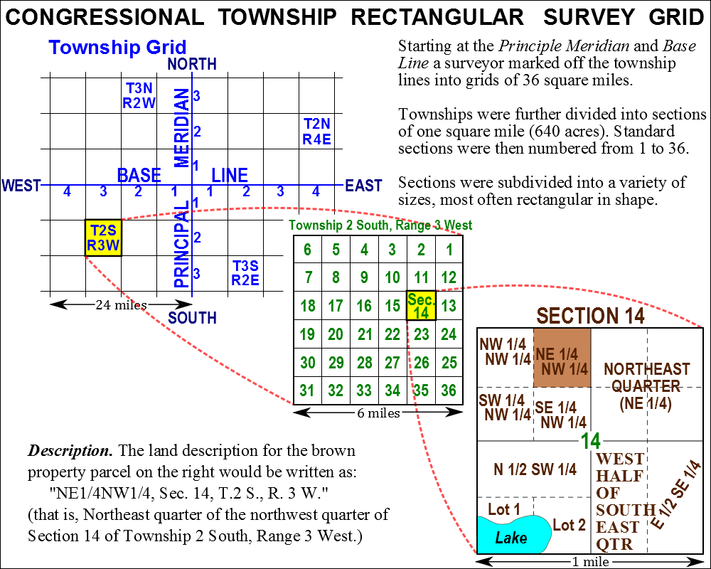
Let’s get to the fun stuff – the pictures. Plat Maps are maps of counties, showing township divisions and numbered sections. It gives us a great overhead view of farm sizes and how those farm sizes follow section lines. Historical plat maps help us with research for the museum. Looking at historic plats and atlases shows that many, many farms were, in fact, 160 acres, in the year 1900. Here’s a portion of the Plat Map of Washington Township in Greene County, Iowa from 1896, where a farmer named Thomas Terrill lived. He kept over 40 years worth of diaries, from the time he was 21 till he died in 1912. The museum has copies of these diaries in our resource library, and they are used as primary sources for historic information. See if you can find his farm.

Some things to note about this picture – there are a few farms that are exactly 160 acres, but nearly all are parcels of land in even fractions of 640. Smaller neighboring parcels of land are also sometimes owned by people with the same surname – presumably family that had been given or sold a portion of the farm. There are two school districts made up of four sections each and their respective schools shown on this piece of the map. The schools are only two miles apart, but that meant that they were within walking distance of all students.
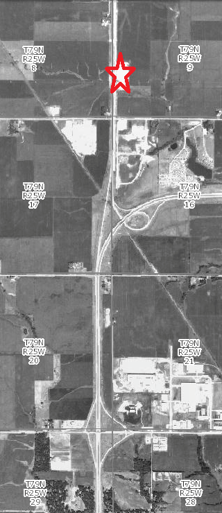
Plat Maps can also show changes in population and land ownership. The last series of pictures I’ll share with you is of where the farmhouse at the 1900 Farm site was originally built in relation to where it sits now. Here is the present day Google satellite image. The current location of the house at the museum is approximately under the “9” of section 29 on the map, in the lower left.

Here is the same area in 1970, just a few years before the house was moved to its current location. The red starred white area on the west side of section 9 is the house’s original farmstead.
And the same area in 1930.

That’s as far back as the aerial imagery goes, but here is the plat map of the same area from 1902. The house was on the Ida Hughes parcel in section 9, which is 120 acres. Pretty close to that 160-acre average. Again, the house today sits almost exactly under the 9 of section 29. The owner of most of the land in sections 28 and 29 should also be familiar if you’ve visited us before. 
As you can see, rural areas were thoughtfully laid out, with schools and churches conveniently located and easy-to-measure parcels of land. Families in these areas related to the township boundaries, just as town families relate to towns, neighborhoods and precincts. Farm families still have that sense of place in their township.
For comparison on population density, here is a plat map image that contains the once-rural town of Waukee, Iowa. Today, Waukee is no longer a rural community, and it is the fastest growing city in Iowa. Dallas County, where Waukee is located, is now one of the fastest growing counties in the U.S.! This is section 33 in Walnut Township, Dallas County, 1916. Remember that this shows one square mile.

It’s neat to look back in time through these tools to see how areas were organized, and how they have developed and changed over time to be what we know today. If you’re feeling inspired, the Iowa DNR has a really neat interactive mapping program on their website that allows users to look at aerial maps of the state from 1930, 1950, 1960, 1970, and today. You can even turn on township and section labels on the maps. Look for the site of your current home in past years!
Interested to learn more about how houses and farms become homes and communities? Visit the House and Home traveling exhibit at Living History Farms before August 11, 2015! The exhibition includes domestic furnishings and home construction materials, photographs, “please touch” interactive components, and films. Together, the objects and images illustrate how transformations in technology, government policy, and consumer culture have impacted American domestic life. The exhibit is free with paid admission to the museum.
This exhibition has been made possible through NEH on the Road, a special initiative of the National Endowment for the Humanities. It has been adapted and is being toured by Mid-American Arts Alliance. House & Home was organized by the National Building Museum, Washington D.C., and curated by Sarah Leavitt. Additional support was provided by the Home Depot Foundation.
Read more posts on the LHF Blog
Categories:
11121 HICKMAN, URBANDALE • 515-278-5286
— THANK YOU TO OUR 2026 PREMIER PARTNERS —
 Official Modern Agricultural Equipment Partner
![]()
![]()
![]()
![]()
Comments